China
China has constructed second village ‘6 kilometres within India’, says report


New Delhi: New satellite images show that China has constructed a second enclave or cluster of at least 60 buildings 6 kilometres within India in Arunachal Pradesh, NDTV reported.
The new enclave did not exist in 2019 according to the satellite images; a year later, it can be seen.
It lies 93 km east of a China-constructed village in Arunachal Pradesh, which was confirmed by a Pentagon report just days ago.
India reacted sharply to that report, stating “China has undertaken construction activities in the past several years along the border areas, including in the areas that it has illegally occupied over the decades. India has neither accepted such illegal occupation of our territory, nor has it accepted the unjustified Chinese claims.”
The second enclave lies approximately 6 kilometres within India in the region between the Line of Actual Control (LAC) and the International Boundary, the report said.
India has always claimed this as its own territory.

The images do not offer any clarity on whether the enclave is occupied.
NDTV quoted the Indian Army as saying, “the location corresponding to the coordinates mentioned in your query lies to the North of LAC (Line of Actual Control) in Chinese territory.”
In a statement in Parliament a year ago, a BJP MP from Arunachal Pradesh had commented on the encroachment by China. Tapir Gao said in the Lok Sabha: “I want to tell media houses in the country that there is no coverage of the extent to which China has captured Indian Territory (in Arunachal Pradesh).”
Referring to the India-China standoff in Doklam in 2017 which lasted several months, Mr Gao warned: “If there is another Doklam, it will be in Arunachal Pradesh.”
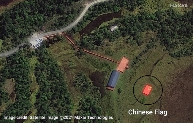
The new enclave, the second of its kind, is established through images from two of the world’s premier satellite imagery providers, Maxar Technologies and Planet Labs.
As per the NDTV report, these images of the Shi-Yomi district of Arunachal show not just dozens of buildings, including a structure with a flag of China painted on a roof top, large enough to be spotted by imaging satellites.
The exact location of the new enclave is clearly indicated on Bharatmaps, a Government of India online map service.
A digital map of India, detailed carefully by the Surveyor General of India, also confirms the location is within India.
“Based on GIS [Geographic Information System] data obtained from the official Survey of India website, the location of this village indeed falls within Indian territorial claims,” said Sim Tack, Chief Military Analyst at the Europe based Force Analysis, which provides data and analysis on armed conflicts and defense policy, NDTV reported.
Free Press Kashmir is now on Telegram. Click here to Join.
FPK Android App for 2G. Click here to Download.