
New Delhi: There are possibilities of two newly formed tropical storms Laura and Marco becoming ‘almost simultaneous threats’ to the US Gulf Coast in the early coming week – as it is being alleged that there are possibilities of it getting sucked into an ‘odd dance’ around each other, as well as ‘falling apart as they soak’ the Caribbean and Mexico this weekend, according to a report by Hindustan Times.
Computer forecast models varied so much that some saw Laura becoming a major hurricane nearing the US, while others saw it dissipating.
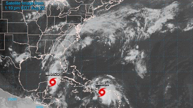
According to the National Hurricane Center forecast, if both storms survive the weekend, Laura would head as a hurricane toward the central Gulf Coast around Louisiana, Mississippi, Alabama and the western Florida Panhandle, while Marco aimed at Texas, though most likely remaining a tropical storm.
“A lot of people are going to be impacted by rainfall and storm surge in the Gulf of Mexico,” said Joel Cline, the tropical program coordinator for the National Weather Service. “Since you simply don’t know you really need to make precautions.” the report carried the quotes.
“Two hurricanes have never appeared in the Gulf of Mexico at the same time, according to records going back to at least 1900, said Colorado State University hurricane researcher Phil Klotzbach. The last time two tropical storms were in the Gulf together was in 1959”, he was quoted saying.
As Laura’s entrance into the Gulf was slowed down by the hurricane and it moved its track westward, the two storms are now forecast to be together in the Gulf on Tuesday, just before Marco smacks Texas with Laura making landfall a bit less than a day later – the report carried.
Tropical storm warnings were in effect early Saturday for Puerto Rico, the US and British Virgin Islands and parts of the Dominican Republic. Laura was forecast to hit Puerto Rico on Saturday morning, go over or near the Dominican Republic and Haiti late Saturday and Cuba on Sunday.
Laura, which set a record for the earliest 12th named storm of a season when it formed Friday morning, was about 70 miles (110 kilometers) southeast of San Juan, Puerto Rico on Saturday morning. It had maximum sustained winds of 40 mph (65 kph) and was heading west at 21 mph (33 kph).
The hurricane center also issued a tropical storm warning and hurricane watch for part of Mexico’s Yucatan Peninsula for Marco, which grew into a tropical storm Friday night.
Saturday morning, Marco was centered about 115 miles (185 kilometers) east-southeast of Cozumel, Mexico, with maximum sustained winds of 45 mph (75 kph). It was headed north-northwest at 12 mph (19 kph).
If the two storms make it, they could be crowded in the Gulf of Mexico at the same time Tuesday about 550 miles apart. That would leave open some weird possibilities, including the storms rotating around each other in a tropical two-step, pulling in closer to each other, nudging each other, weakening each other or — far less likely — merging.
Citing both storm systems, Louisiana Gov. John Bel Edwards declared a state of emergency Friday night. “It is too soon to know exactly where, when or how these dual storms will affect Louisiana, but now is the time for our people to prepare for these storms,” he was quoted saying.
Meteorologists said Marco has a ‘better chance of surviving’ its early land encounter, then ‘strengthening to a minimal hurricane over warm water’, but the hurricane center was forecasting it to weaken before it reaches the US Gulf Coast because of decapitating high winds.
Free Press Kashmir is now on Telegram. Click here to Join.