
2014 did to Kashmiris what many years of battered conflict couldn’t do. Such a shocker however, has not served as a wakeup call. In fact, more and severe damage has been done to the city post the deluge.
While wrongs have been done, no lessons have been learnt.
“I don’t know who’s on the wrong side,” says Saleem Beg, chief of the INTACH chapter JK. “Srinagar has been developed in disaster-prone areas. There’s an inherent problem with the city layout.”
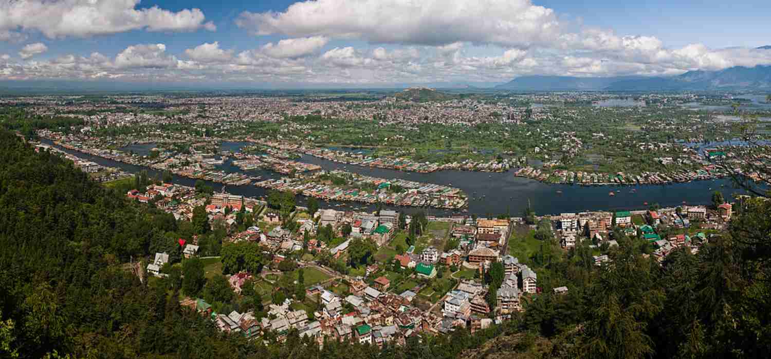
Currently mired in the shoddy and sordid state of affairs, Srinagar took centuries to come up where it’s right now.
It was built on the foothills of Koh-e-Maran — first by Parwarsen, then the Sultanate and finally by the Mughals.
Parwarsen built it towards Bahauddin Sahib. Then Zain-ul-Abidin expanded it to Jamia Masjid.
“Then Mughals went much higher than Jamia Masjid towards Kathi Darwaza and upwards,” Beg says. “The reason was that the city was flood prone and the rest of it was marsh.”
While ‘elites’ moved towards Kathi Darwaza, they left behind ‘outsiders and low castes’ in marshy shelters.
“Among the city dwellers were rulers, their servants, staff and the traders,” Beg continues. “They used to employ people from outside who were lower castes and they used to be put in temporary shelters in the marshy part of the city.”

Saleem Beg, chief of the INTACH chapter JK
But not only did the construction happen at the wrong places in the city, but in wrong ways, too.
Once the natives populated the city’s disaster-prone areas, they began having a face-off with Nature. Living in the wrong places mostly proved a misadventure for them.
At times, it took a few days of rain to inundate their dwellings and drive them out.
ALSO READ: How conversion of Bemina from flood basin to residential area endangered Srinagar
Earlier, people built their houses with embankments near Jhelum, as it was the defining highway for Srinagar. “We didn’t have a road,” Beg says.
Subsequently, the city developed, the way it develops all over the world: in an organic way. Things happen by default.
“At times people become complacent,” Beg continues the city’s chronicle. “We did not only build at the wrong places, but also in the wrong way.”
Interestingly, the first ever Srinagar Master Plan (drafted for 1970-2001) stressed on the need of flood and disaster prevention.
For floods, two huge lakes were proposed.
One lake would’ve covered area beyond Jawahar Nagar up to the present day Bypass area. It would’ve been a listed lake in 1974. Another lake was in Bemina area.
“So we knew, as early as in 1974 that flood basins should be made,” Beg says. “But since no floods occurred after ’74, people just forgot and started constructing in these zones.”
Back then, nobody would’ve even thought of Chanapora as a residential colony. It was supposed to be a lake!
ALSO READ: The day Jhelum, the poet’s muse, went loose…
And even when land in Rajbagh area was being sold at Rs 60,000-80,000 a kanal during late ’80s, nobody built a house in Mehjoor Nagar, where land was valued Rs 5000 per kanal.
It was so, because everyone knew that it was a flood-prone area.
“However, we lost this in our memory that flood is a possibility,” Beg, turning thoughtful inside his Srinagar office, says. “And then 2014 happened, and we saw how those proposed lakes [Jawahar Nagar and Bemina] suffered badly in floods.”
The water didn’t spare even the so-called ‘safe areas’. As Jhelum went berserk, the flood waters spilled over Hari Singh High Street and Lal Chowk, the city’s trade heartland.
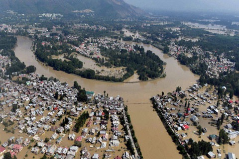
An aerial view of flooded Srinagar in 2014.
If one sees the geography of Kashmir, area between Chount Kul and River Jehlum is an island — the supposed safe area. This island was a grassland and there was no habitation here until early 20th century.
It was used to feed horses which used to ply between Muzaffarabad and Srinagar. People knew that the left side of the Jhelum is a flood basin (no-construction zone) and the right side an island.
But when Imperial British first arrived in the valley, this no-construction zone started changing.
“They needed quarters and they knew that they need secure areas,” Beg says.
ALSO READ: Remembering September 2014 Floods in Poetry
“So they looked at this island from a very different angle, from the ‘security angle’. So nothing would come from Jhelum or the Chount Kul. They declared the area as urban quarters, from Amira Kadal, where the island starts, and ends near Dalgate.”
Before that, the city was built on fairly secure areas. And when it expanded, it did on temporary quarters for ‘menials’ essentially. And the rest was agriculture.
“Later on, it was our greed, and more than greed, our compulsion that we expanded, as Srinagar has land scarcity,” Beg says. “You need land for agriculture, horticulture, rivers, lakes and human beings, too. And we built at whatever land was available. So I don’t know who to blame.”
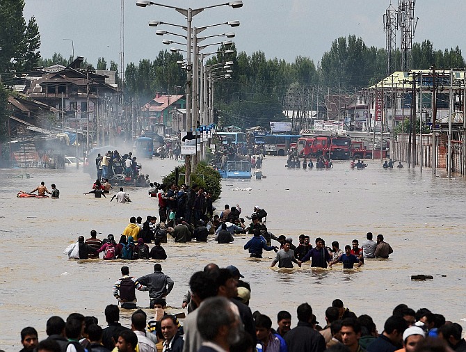
Kashmir floods. (File Photo)
But when European quarters came up in the city’s south end, the seat of power swiftly shifted to that side. It led to a slow and gradual departure from north, Jamia Masjid. People headed south, to create their new addresses.
This internal migration eventually gave rise to Rajbagh, Ram Munshi Bagh and Jawahar Nagar localities.
However, the rulers, mindful of city’s flood history, always preferred lofty zones. Location of Oberoi Palace and Gupkar Road—the twin flood-immune power centres—only makes it certain.
But as the inorganic city growth created land scarcity, questions were also posed on huge swathes of land under the occupation of Indian Army in Srinagar.
Is that also a reason for land crisis in city?
Beg feels that more than a reason, it’s a statement.
“Well, cantonments too, are not secure places,” he says. “In 2014, both Badamibagh and Tatoo ground in Srinagar were flooded.”
And since Kashmiris like to build in plains, rather than on hills, BB Cant plain area is as prone to floods as any other area. And hilly part won’t be preferred by Srinagar people for residence.
“But then,” Beg says, “if you’ve land in secure areas and that land is occupied by cantonments, that does make a statement!”
To be continued…
Next: How Bemina choked Srinagar
Like this story? Producing quality journalism costs. Make a Donation & help keep our work going.